
Robotics research often moves from simulations to real-world testing, and when that happens researchers need dependable platforms they can build on. Clearpath Robotics robots frequently show up in academic projects for exactly this reason—they’re rugged, flexible, and easy to integrate with different sensors and software stacks.
In this post, we’re highlighting a few recent research papers where Clearpath platforms were spotted in the wild, including projects that used the Warthog, Husky, and Jackal for off-road navigation, agricultural autonomy, and multi-robot collaboration in GPS-denied environments. These examples give a quick look at how researchers are using these platforms to test new ideas in real-world settings.
Temporally Sampled Efficiently Adaptive State Lattices for Autonomous Ground Robot Navigation in Partially Observed Environments
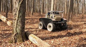
Researchers at the University of Rochester present a new motion-planning approach called TSEASL that helps autonomous ground robots navigate more smoothly in environments where they can’t see everything at once. This is a common challenge for robots operating in places like forests or other off-road settings—new obstacles constantly appear as sensors gather more data.
Traditional planners often recompute paths every cycle, which can cause the robot to rapidly switch between different routes and behave unpredictably. TSEASL tackles this by considering both newly generated paths and previously selected ones, allowing the robot to adapt to new information while sticking with stable, reliable trajectories when possible.
To test the approach in the real world, the team ran experiments on a Warthog navigating through a dense forest. Using this platform allowed the team to evaluate their planner on real terrain with natural obstacles like trees and vegetation, rather than relying on simulation alone.
The results were promising: Warthog followed smoother, more consistent paths and avoided the unstable behavior seen with the baseline planner. Thanks to Warthog’s reliable hardware and off-road capability, the team was able to demonstrate that their planning method can improve the safety and reliability of autonomous navigation in complex outdoor environments.
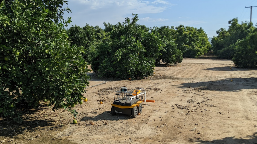
Robotic Mapping of Soil Volumetric Water Content with Geospatial Soil Apparent Electrical Conductivity in Micro-Irrigated Citrus Orchards in California
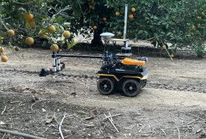
This research team at the University of California Riverside explored new ways to improve autonomous navigation for agricultural robots operating in orchards—environments that can be surprisingly challenging for robots. Tree rows, uneven terrain, and changing lighting conditions can all make it difficult for robots to accurately determine their position and stay on course.
The study proposes an improved localization and navigation approach that combines sensor data with probabilistic filtering techniques to help the robot better estimate where it is relative to the orchard rows. By continuously updating its position and correcting for drift or sensor noise, the system helps the robot stay centered between rows and navigate more reliably through the field.
To evaluate the approach in real-world conditions, the researchers used a Jackal equipped with sensors such as LiDAR to perceive its surroundings. Jackal provided a robust and flexible testbed for field experiments, allowing the team to deploy their algorithms directly in a commercial orchard environment.
During testing, the robot autonomously navigated long distances between tree rows with smooth motion and minimal deviation from the desired path, demonstrating that the proposed method could improve navigation accuracy and reliability for agricultural robotics applications.
“This research gives citrus growers a practical way to see how water is distributed across their orchards, tree by tree, rather than relying on a few scattered sensors. With the help of autonomous robotic platforms, this kind of detailed monitoring can be carried out across entire orchards, helping growers use water more efficiently, keep trees healthier, and maintain productivity. Precision soil-moisture sensing like this could play an important role in helping the citrus industry adapt to increasing water scarcity.” – Elia Scudiero
SwarmBuild: Decentralized Multi-Robot Collaborative Mapping and Autonomous Assembly in GPS-Denied Environments
This paper explores how teams of robots can work together to map unknown spaces and build structures without relying on GPS or a central controller. Instead of a single robot doing all the work, the SwarmBuild system uses a decentralized swarm where each robot shares local information with nearby teammates to gradually build a shared map of the environment.
As the fleet of robots explore, they coordinate tasks like transporting materials and assembling components, allowing the group to autonomously construct structures while continuously updating their understanding of the surroundings. This decentralized approach makes the system more scalable and resilient—if one robot fails, the rest of the swarm can continue the mission.
To demonstrate the concept, researchers from Georgia Institute of Technology, University of Cincinnati, and Clemson University tested the system using a heterogeneous group of robots, including aerial drones and Husky A200. Husky played an important role as a reliable ground robot capable of carrying sensors and interacting with the construction environment while collaborating with the aerial robots. Thanks to its rugged design and flexible integration capabilities, Husky served as a stable mobile platform for testing collaborative mapping and coordination in GPS-denied environments. The experiments show how combining different types of robots—along with decentralized mapping and task coordination—can enable swarms to explore unfamiliar spaces and autonomously carry out complex construction tasks.